
Help with the Research
The process of cleaning up marine debris begins by taking surveys of affected areas using technologies such as sonar and airborne lidar. The collected data is then processed using automatic target detection algorithms, which identify possible debris in the datasets we collect. Finally, trained analysts then look at each of these targets to work out whether they are natural features, or man-made objects that should be cleaned up.
However, after a large-scale disaster like Super Storm Sandy, there can be far too many debris targets and not enough trained analysts to look at all of them. We are interested in learning if the general public, even if they are not formally trained, can help perform these analyses in order to aid speedy disaster response.
The interface on the bottom of this page allows you to view actual potential marine debris targets from areas affected by Super Storm Sandy. We’d appreciate your help in identifying debris, so that we can use the results to help the effort to clean up. What we learn will also be used to help future clean-up efforts after the next big storm.
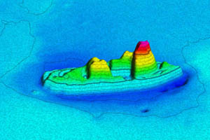
An example of marine debris
Identifying marine debris can be tricky. Sometimes you can immediately tell what an object is, or at least that it doesn’t look natural, such as this shipwreck:
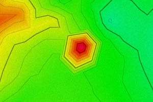
An example of a low-resolution target
However, sometimes the data is very low-resolution, and you might just notice a bump like the one in the picture to the left.
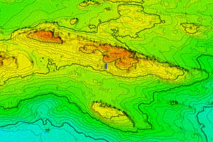
An example of a natural feature
In these cases, look at the surrounding area. If it’s mostly smooth and there is a big bump sticking out, that is likely to be debris. However, sometimes an area is just very rocky all over like this, which can confuse the detection algorithms:
Privacy Notice: We will never email or spam you. All user data is private. Interaction data will be anonymized and used to evaluate the effectiveness of our visualization techniques.


